Mesh Rider GPS Guide
Introduction
The purpose of this guide is to instruct the user on how to configure and view the status of the GPS receiver. GPS is available in Wearable Mesh Rider Radios. Further information on the default GPS receiver can be found here. The module used is the U-Blox MAX M8Q. Here are the feature highlights:
- The GPS receiver supports the concurrent reception of following satellite constellations:
- GPS L1C/A
- SBAS L1C/A
- QZSS L1C/A
- GLONASS L1OF
- BeiDou B1
- Galileo E1B/C
- General Specifications
- 2.5-m accuracy
- -167 dBm tracking sensitivity
- 0.05 m/s velocity accuracy
- 10 Hz max fix rate
- SBAS, QZSS, RTCM 2.3 Differential GPS
Hardware Configuration
The Wearable Smart Radio includes an female SMA connector where the supplied active GPS antenna shoud be connected. No configuration is required, but the antenna requires a view of the sky in order to work.
GPS Configuration
The GPS receiver configuration page in the web GUI under System -> GPS receiver. This page is only accessible after clicking the Advanced Settings button at the bottom left corner of the screen. Figure 1 shows a screenshot of the page. After making any changes, click Save & Apply.
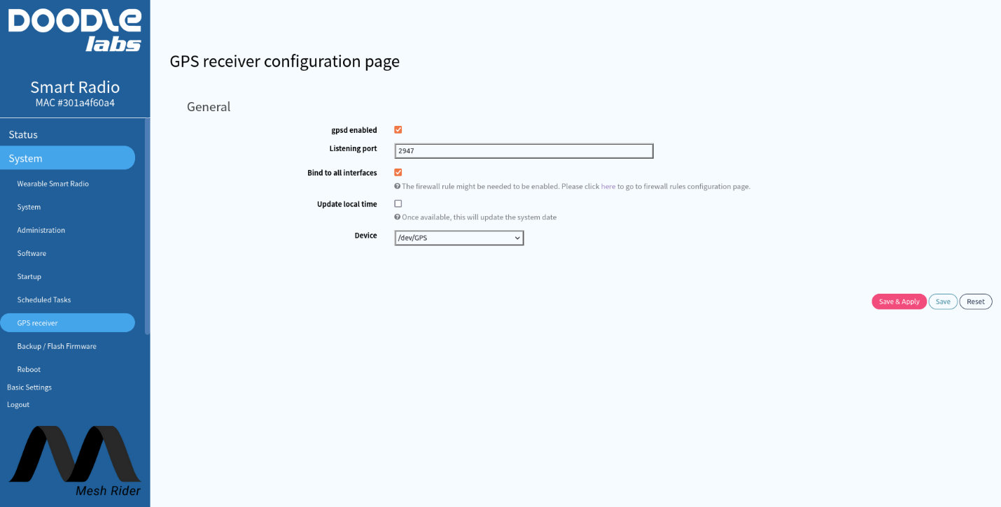
Fig. 1 GPS receiver configuration page
These settings can also be configured through the radio's command prompt. SSH into the radio, and check the UCI configuration using
root@smartradio:/etc/config# uci show gpsd
gpsd.core=gpsd
gpsd.core.enabled='1'
gpsd.core.device='/dev/GPS'
gpsd.core.port='2947'
gpsd.core.listen_globally='0'
If you want to access gpsd directly from another host machine, you need to enable bind to all interfaces (listen_globally in UCI).
GPS Status
The GPS receiver’s status is shown in the Status -> Overview webpage. An example output is shown in Figure 2.
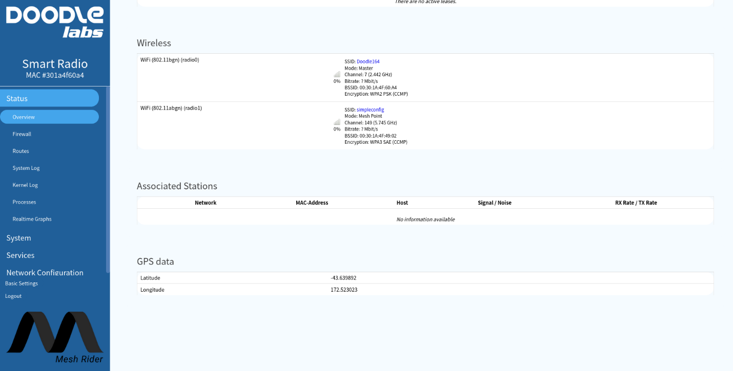
Fig. 1 GPS Coordinates
It is also possible to remotely poll the GPS status using any of the methods described in the Remote Management Guide. Simple GPS data is retrievable from the folder /var/run/gps/
root@smartradio:~# ls /var/run/gps
altitude   driver     latitude   longitude  time
You can also get more information using the gpspipe or cgps utilities.
root@smartradio-301a4f60a4:~# gpspipe -w -n 5
{"class":"VERSION","release":"3.17","rev":"3.17","proto_major":3,"proto_minor":12}
{"class":"DEVICES","devices":[{"class":"DEVICE","path":"/dev/GPS","driver":"u-blox","subtype":"SW ROM CORE 3.01 (107888),HW 00080000,FWVER=SPG 3.01,PROTVER=18","activated":"2021-12-10T00:47:49.985Z","flags":1,"native":1,"bps":9600,"parity":"N","stopbits":1,"cycle":1.00,"mincycle":0.25}]}
{"class":"WATCH","enable":true,"json":true,"nmea":false,"raw":0,"scaled":false,"timing":false,"split24":false,"pps":false}
{"class":"TPV","device":"/dev/GPS","mode":3,"time":"2022-08-09T22:53:39.000Z","ept":0.005,"lat":-43.639926938,"lon":172.522991254,"alt":10.314,"epx":9.100,"epy":12.052,"epv":38.410,"track":135.1323,"speed":0.010,"climb":-0.022,"eps":0.44,"epc":76.82}
{"class":"SKY","device":"/dev/GPS","xdop":0.72,"ydop":0.96,"vdop":1.67,"tdop":1.31,"hdop":1.19,"gdop":2.43,"pdop":2.05,"satellites":[{"PRN":3,"el":17,"az":338,"ss":36,"used":true},{"PRN":4,"el":79,"az":20,"ss":31,"used":true},{"PRN":7,"el":23,"az":263,"ss":26,"used":false},{"PRN":8,"el":13,"az":18,"ss":28,"used":true},{"PRN":9,"el":58,"az":237,"ss":34,"used":true},{"PRN":16,"el":66,"az":112,"ss":29,"used":true},{"PRN":26,"el":39,"az":127,"ss":31,"used":true},{"PRN":27,"el":30,"az":53,"ss":10,"used":false},{"PRN":194,"el":22,"az":316,"ss":33,"used":true},{"PRN":65,"el":71,"az":296,"ss":26,"used":true},{"PRN":72,"el":33,"az":10,"ss":35,"used":true},{"PRN":75,"el":72,"az":215,"ss":20,"used":true},{"PRN":76,"el":28,"az":291,"ss":21,"used":true}]}